Maps API use cases, features, and real-world examples
If you're a developer looking to integrate location-based features into your applications, a maps API is the first step to getting started. Maps APIs allow you to build local search functionality, optimize delivery routes, create store locators, and bring real-world geographical data into your digital products.
Whether you're new to integrating maps or you're looking to refine your implementation, in this guide we'll provide a comprehensive overview to using maps APIs effectively in your projects.
Introduction to mapping APIs
A maps API (Application Programming Interface) is a set of tools that enables developers to embed mapping, location-based data, and related functionalities into websites or applications. Common maps APIs include the following tools: map features, geolocation services, and geographic data (such as addresses, coordinates, and place details).
Breaking down the key components of a maps API
With a maps API, developers can display and customize interactive maps, perform geocoding, search for locations, plot routes, create static maps, and use autocomplete components. Let's explore these different functions and additional features.
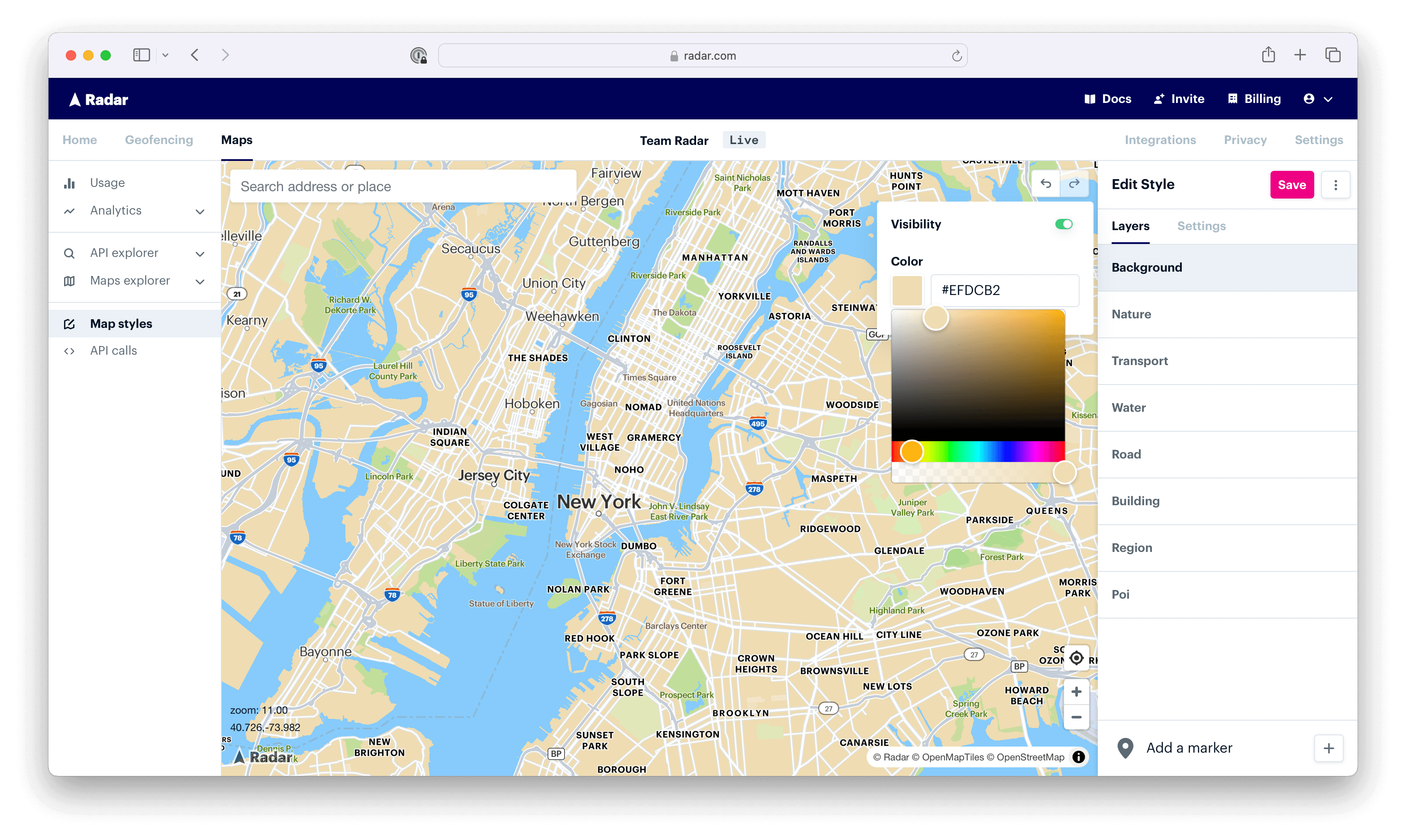
1. Base maps
You'll rarely make it through your day without encountering an interactive map, whether in a mobile app or while browsing on your desktop. Commonly used for food delivery or locating stores and businesses, customizing interactive maps make user experiences more branded and engaging.
By initializing the Radar SDK with your publishable key and rendering the map into a specified container, you can easily embed an interactive Radar map into your web, iOS, or Android mobile app. Customization options allow you to adjust everything from map styles and colors to markers and more.
2. Geocoding APIs
When you type your address into a map, have you ever wondered how it populates such accurate results near your location? After all, there are likely many places named 123 Main Street. The answer? Geocoding.
By connecting real-world locations with digital systems, geocoding APIs help businesses validate addresses, conduct location-based searches, and trigger proximity-based notifications. Geocoding APIs are commonly used for logistics, travel, and e-commerce, where location is a core component of user experiences. Here are three common types of geocoding:
- Forward geocoding converts addresses, like
1600 Amphitheater Parkway, Mountain View, CA, into their corresponding latitude and longitude coordinates. These coordinates can then be used to place markers on a map or position the map. - Reverse geocoding, as the name implies, does the opposite. It involves converting geographic coordinates into a human-readable address. So, if you have a set of coordinates (for example,
37° 25' 17", -122° 5' 3"), reverse geocoding would provide you with1600 Amphitheater Parkway, Mountain View, CAor a recognizable location name that's understandable. - IP geocoding is slightly different. It's the process of mapping an IP address to a geographic location. Though not as precise as the other methods, it's useful when GPS data isn't available or when street-level precision isn't necessary.
Want to see it in action? Take a look at a forward geocoding example below. See how entering a structured address is converted into latitude and longitude coordinates. To get started with geocoding APIs, reference the documentation here.
3. Search APIs
The datasets for locations, addresses, and points of interest are vast. With search APIs, developers can integrate powerful search functionality into their applications, enabling users to retrieve relevant data efficiently.
Using various filters, keywords, and proximity-based parameters, developers can set rules for applications across a range of use cases, like e-commerce and delivery platforms.
Common endpoints for search APIs include:
- Address autocomplete, as the name implies, is an application feature that suggests address options as a user types, speeding up the input process and improving accuracy by reducing user errors. You’ll also see this referred to as address suggestion, typeahead, auto-suggest, or auto-fill.
- Address validation, on the other hand, is the process of checking a physical mailing address against an authoritative database to determine if it's a valid, deliverable address. You’ll also see this referred to as address verification.
- Places search allows users to search for places by chain (e.g., McDonalds) or category (e.g., airport) across a points-of-interest (POI) dataset, covering millions of locations worldwide.
4. Route optimization APIs
Route optimization is the process of finding the most efficient route through a series of waypoints. For example, a delivery driver might have multiple drop-offs, and you might want to find the shortest and most fuel-efficient route. Or, a worker might have multiple jobs, and you might want to determine the most efficient sequence in which to complete them.
While you can plan routes manually, this can be tedious and complicated. If you have a few vehicles with 10 stops each, there are millions of different route possibilities.
Often called the Traveling Salesman Problem (TSP) or Vehicle Routing Problem (VRP), computing an optimal route is notoriously challenging. Instead, it can be much more effective to use a route optimization API or route optimization software.

Common route optimization APIs include:
- Distance API calculates the travel distance and duration between an origin and a destination, supporting various travel modes like walking, biking, and driving. It's useful for estimating trip times, ETAs for pickups or deliveries, and determining the distance to nearby locations.
- Matrix API calculates travel distances and durations between multiple origins and destinations, ideal for use cases like determining walking or driving distances to nearby stores in a store locator or optimizing multi-stop routes.
- Route matching API snaps GPS points along a traveled path to the most likely roads, producing clean, accurate routes for display, mileage tracking, and retrieving road information like speed limits and road names.
- Directions API calculates the most efficient route between two or more locations, making it perfect for displaying routes on a map or providing navigation between multiple stops.
- Route optimization API determines the best sequence and route for visiting multiple locations, commonly used for optimizing pickups, deliveries, or multi-stop routes.
Exploring real-world use cases of maps APIs
Now that we've explored the variety of maps API components, let's take a look at some examples in action.
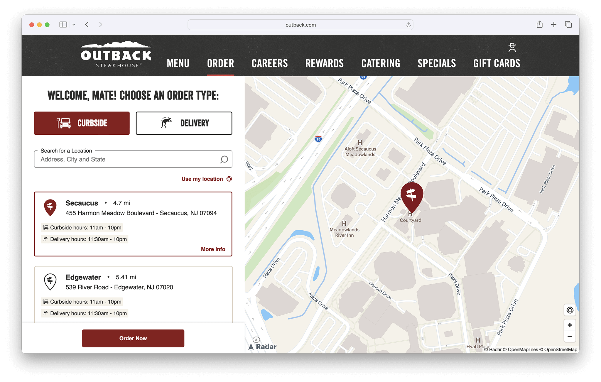
Outback Steakhouse uses forward geocoding on their store locator to help customers convert their address to coordinates and find restaurants near them.
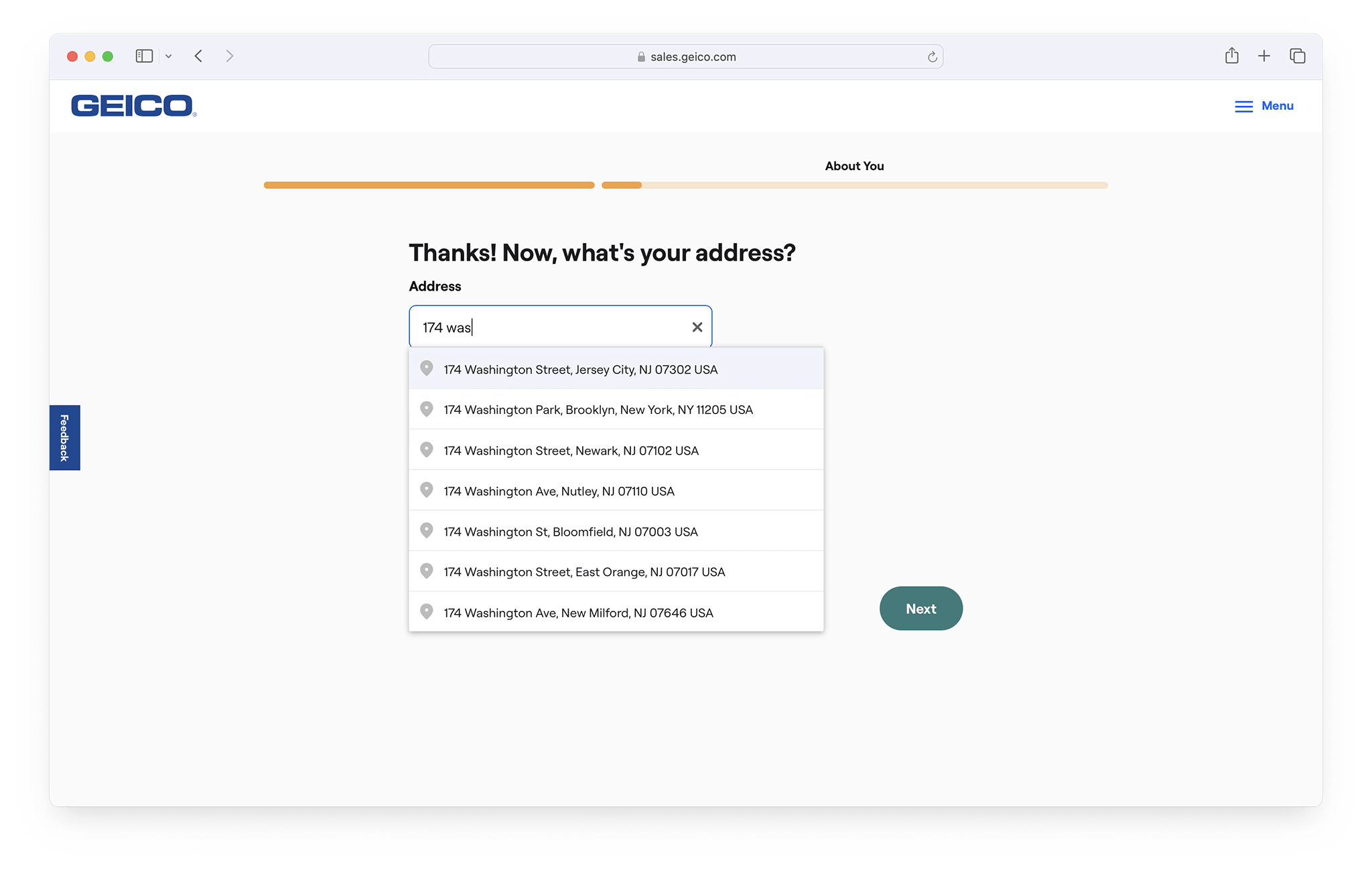
GEICO helps customers tailor insurance plans and validate their addresses to get faster quotes.
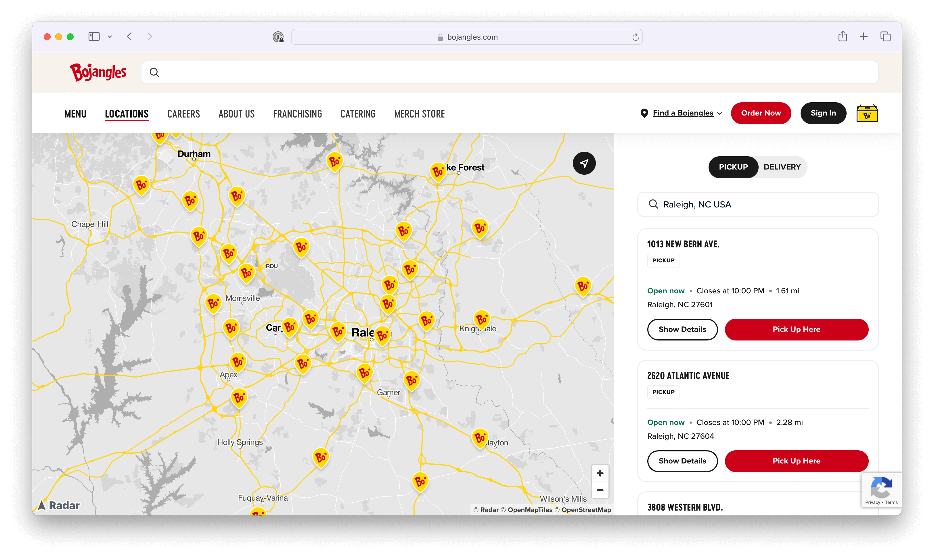
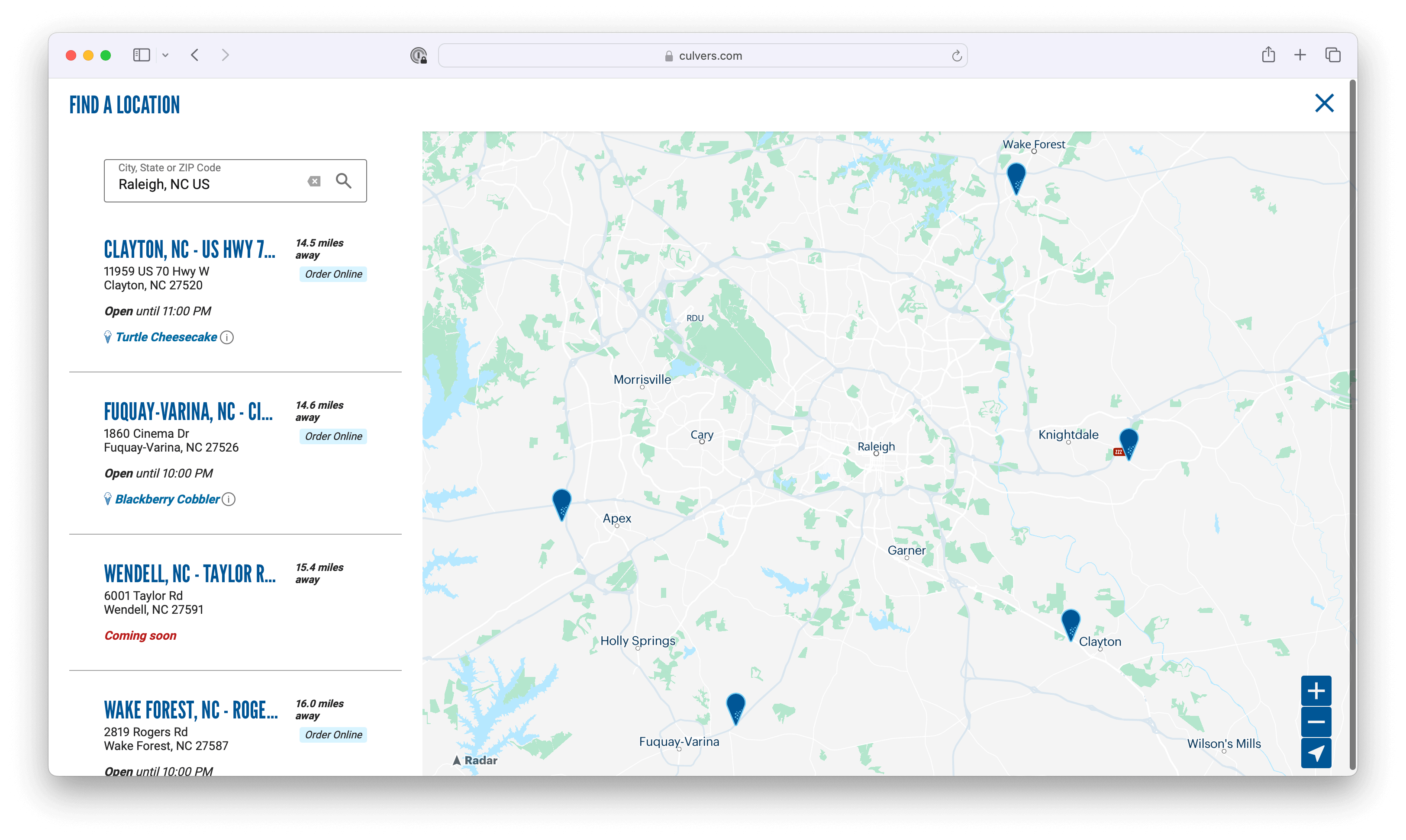
Bojangles and Culver’s are using dynamic maps to customize their store locators. With Radar's Maps Platform, they're able to integrate custom styles that match their brand guidelines.
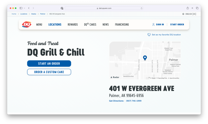
Dairy Queen, on the other hand, is using static maps to customize their store locator. With the Radar Static Maps API you can generate standalone images of maps that can easily be embedded anywhere an image can be used.
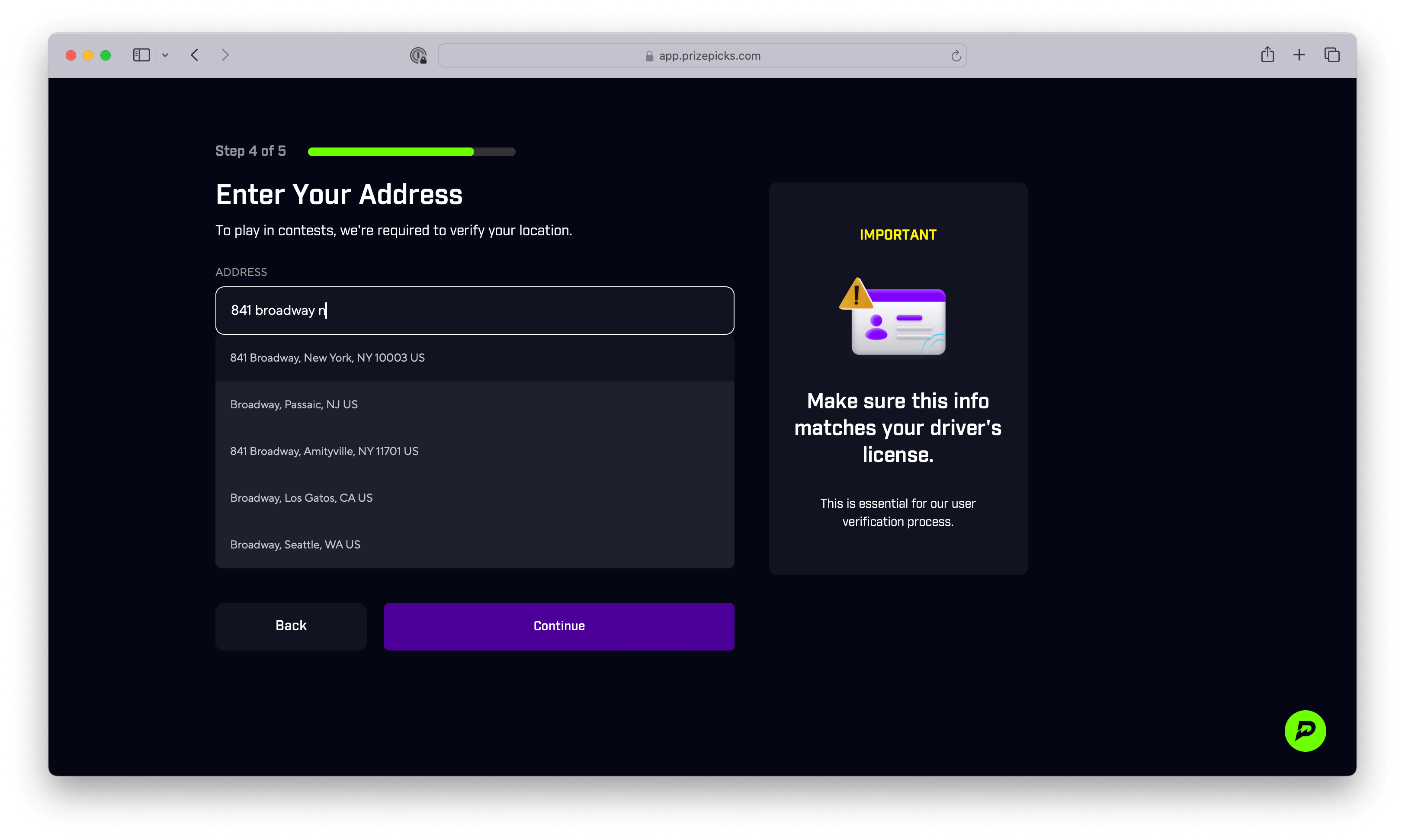
PrizePicks requires players to verify their identity in their signup flow. To reduce friction and boost conversion, they use autocomplete to help users more easily enter their address.
3 benefits of using a maps API
We've now gone over examples of maps APIs and the different components they are composed of. So, what are the key benefits? Across industries and use cases, the main benefits of using a maps API are:
1. Enhanced user experience
A picture says a thousand words. When it comes to improving conversion rates and retaining users on your website or mobile app, interactive and easy-to-use maps are key. Visualizing locations, finding nearby services, and validating addresses, are key to engagement and usability.
2. Improved business insights
Mapping APIs allow businesses to study location data and reveal trends in customer interactions. Whether you're using autocomplete at checkout for your e-commerce business or forward geocoding for your store locator, every interaction, conversion, and drop-off can be measured in your funnel.
3. Customization and flexibility
With mapping APIs you can create custom map styles with your own fonts, colors, logos, and more, helping you build branded experiences that drive more engagement and higher conversion rates.
Popular maps APIs
You have a variety of options available when selecting your maps API. Key factors to consider include price, the level of customization you need, and the ease of integration. Take a look at some of the top options:
Radar
The Radar Maps Platform is the affordable, all-in-one solution: with cost-effective geocoding APIs, search APIs, routing APIs, and base maps. Radar is typically 50-90% less expensive than Google Maps and Mapbox, and supports 99.99%+ uptime as well as enterprise-grade address coverage around the world. You can also make up to 100,000 API requests per month for free.
Google Maps API
The Google Maps API provides access to a vast collection of mapping, geolocation, and navigation services. Widely used in web and mobile apps, Google Maps is the most recognizable company in the space, and the most expensive.
Mapbox
Mapbox provides a customizable maps platform that lets developers design and embed interactive maps, with real-time updates. It's nearly as expensive as Google Maps, and its functionality is useful for a limited number of use cases.
Bing
Bing Maps API offers a range of geocoding, traffic information, and imagery services. Powered by Microsoft, it's often chosen when integrating with other Microsoft tools. However, it lacks visually appealing vector maps, open-source SDKs, and developer-friendly documentation.
Azure
Azure Maps is Microsoft's mapping platform designed to integrate geospatial services. It's optimized for enterprise solutions and comes at a high price point.
Ready to create?
If you're a developer looking to create location-based applications, you'll need to begin exploring maps APIs. With the right API, developers can create immersive experiences, optimize routing and navigation, and provide location intelligence.
When it comes to picking a scalable API for your needs, Radar is the all-in-one geolocation solution. Get started for free here.