12 best Mapbox alternatives in 2026
For many developers, Mapbox has been a popular choice for integrating maps and location services into apps. However, as the landscape of mapping APIs evolves, alternatives are emerging that offer distinct advantages in cost, customization, and specialized features.
In this article, we'll explore the top alternatives to Mapbox, why developers are considering these options, and how they might provide the perfect solution for your next location-based project.
Why consider an alternative to Mapbox?
Cost: Mapbox operates on a freemium model, and while their free tier is generous, high-volume usage can get expensive quickly. Some alternatives offer more competitive pricing or even completely free options for certain use cases.
Customization limitations: While Mapbox offers customization, some users might find it restrictive. Alternatives might provide more control over map styles, data sources, or specific features.
Performance concerns: In some cases, developers might experience performance issues with Mapbox, such as slow loading times or occasional glitches. Alternatives might offer better performance or more optimized solutions for specific applications.
Feature gaps: Mapbox may not have every single feature a developer needs. For example, some alternatives might offer better offline capabilities, more advanced routing options, or specialized features like indoor mapping.
Data ownership and privacy: Using Mapbox means sharing data with a third-party provider. Some users might prefer alternatives that prioritize data privacy or give them more control over their data.
Open-source preference: Some developers prefer open-source solutions for greater transparency and community-driven development. OpenStreetMap, for example, is a popular open-source alternative.
Vendor lock-in: Relying on a single provider like Mapbox can create vendor lock-in. Some users might prefer alternatives that offer greater flexibility to switch providers or use multiple solutions.
Specific industry needs: Some industries might have unique requirements that are better met by specialized mapping providers. For example, HERE Technologies caters to the automotive and logistics industries, while Radar focuses on geofencing and location tracking.
Key features to look for in a Mapbox alternative
Core mapping features
Global coverage: Ensure the alternative has comprehensive and accurate map data for the regions you need.
Zoom levels: A wide range of zoom levels is essential for detailed views and broader perspectives.
Points of interest (POI): A rich database of POIs (restaurants, businesses, landmarks) is crucial for many applications.
Geocoding and reverse geocoding: Accurate conversion between addresses and coordinates is fundamental.
Routing and Navigation: If your application requires directions, evaluate routing algorithms, transport modes supported (car, pedestrian, bicycle, public transit).
Customization and flexibility
Map styling: Control the visual appearance of your maps to match your brand or application's aesthetics.
Custom markers and overlays: Add your own markers, icons, and layers to represent specific data or points of interest.
Data integration: Seamlessly integrate with your own datasets or third-party data sources.
Technical considerations
APIs and SDKs: Robust and well-documented APIs and SDKs for various programming languages are essential for easy integration.
Performance and reliability: Fast loading times and reliable uptime are critical for a good user experience.
Offline access: If your application needs to function without internet connectivity, consider alternatives offering offline maps.
Pricing and support
Cost-effectiveness: Evaluate pricing models (e.g., per request, subscription-based) and compare them to your budget and usage needs.
Free tier: A generous free tier can be beneficial for testing or low-volume usage.
Support and documentation: Comprehensive documentation, tutorials, and responsive support channels can save you time and effort.
Data privacy and security
Data ownership: Understand how the alternative handles your data and whether you retain ownership.
Privacy policy: Review the provider's privacy policy to ensure it aligns with your requirements.
Top 12 Mapbox alternatives on the market right now
- Radar
- MapTiler
- Maptive
- ArcGis by Esri
- OpenStreetMap
- Google Maps Platform
- OpenLayers
- Maplibre
- Carto
- Azuere Maps
- QGIS
- Bing Maps
1. Radar
Radar is a comprehensive location infrastructure and intelligence offering a compelling alternative to Mapbox. In addition to a comprehensive set of maps APIs, Radar provides powerful geofencing capabilities, accurate location tracking, and place detection, enabling developers to build location-aware applications across various industries. With its focus on cost-effectiveness, ease of integration, and privacy, Radar is ideal for businesses looking to enhance user experiences with precise and efficient location services.
Key features of Radar
Complete set of maps APIs: With geocoding APIs (forward, reverse, IP), search APIs (autocomplete, address validation, places search), routing APIs (distance, matrix, route optimization, route matching, directions), and base maps, Radar has it all.
Enterprise ready and flexible: Radar handles over 100 billion API calls per year from over 100 million devices. Radar is easy to integrate and allows for flexible usage and data caching to fit your architecture.
Global coverage: Radar incorporates open and commercial datasets for maximum coverage at an affordable price.
Cost-effective and reliable: 50%-90% less expensive than Mapbox and enterprise ready. Radar is free up to 100,000 requests per month and only $0.50 for every 1,000 calls after that, with volume discounts available.
Beautiful vector basemaps: Radar provides visually appealing and customizable vector basemaps in classic, dark, and light themes. These maps are designed to be performant and can be easily integrated into your website or application using the Radar JavaScript SDK. This allows for flexibility in design and creates a visually engaging user experience for your users.
Powerful and flexible geofencing: This is a core strength of Radar. It goes beyond basic circular geofences, offering precise shapes like polygons for accurate boundaries around complex areas, advanced triggers like "dwell time" (how long someone stays within a geofence), chained geofences that trigger actions based on sequences of geofences, and time-based geofences that activate only during specific times.
Developer friendly experience: Radar is designed for easy integration with well-documented SDKs for various platforms, remote configuration, and pre-built integrations with other tools. Its open-source SDKs provide transparency and community support. The platform also includes a dashboard and tools to visualize geofences, manage locations, debug issues, and analyze data.
Privacy and compliance: Radar prioritizes user privacy and data security. It is GDPR and CCPA-compliant, offers customizable tracking options to balance accuracy with privacy and battery usage, and ensures that you retain control of your location data.
Why do companies choose Radar over Mapbox?
Here are some key features that make Radar a strong Mapbox alternative:
- Cost-effective solution: Radar is significantly more affordable than Mapbox, boasting cost reductions of 50-90%. This makes it an attractive option for companies seeking powerful location features without excessive expenses.
- Precise geofencing: Companies who switch to Radar for maps can utilize the additional savings to fuel their geofencing projects. While it's not a direct feature of the maps platform itself, Radar offers highly accurate geofencing with customizable shapes and support for advanced use cases like time-based triggers and stop detection.
- Comprehensive mapping features: Provides essential mapping features like geocoding, routing, and search, ensuring that you have the core tools needed for location-aware applications.
- Cross-platform compatibility: With SDKs for iOS, Android, React Native, Flutter, and Web, Radar enables you to build location-based features across different platforms with a consistent and unified approach.
- Developer-friendly tools: Offers open-source SDKs, comprehensive documentation, and a user-friendly dashboard for easy integration and management of location services.
- Scalability and reliability: Radar's infrastructure is designed to handle high volumes of requests and ensure reliable performance, making it suitable for growing applications.
- Privacy-focused approach: Prioritizes user privacy and data security with customizable tracking options and transparent data handling practices.
Radar documentation
- Documentation - Overview | Radar
- Documentation - Maps | Radar
- Documentation - Autocomplete | Radar
- Documentation - API Reference | Radar
- Documentation - Geocoding APIs | Radar
- Documentation - Routing APIs | Radar
2. MapTiler
MapTiler is a platform that provides customizable maps, easy-to-use tools, and comprehensive datasets for developers and businesses. It offers a user-friendly interface for creating and styling maps, along with APIs and SDKs for integrating those maps into various applications. MapTiler is a good alternative to Mapbox if you need a simple and affordable way to create custom maps with global coverage and offline capabilities.
Key features
Customizable maps: MapTiler allows you to customize the look and feel of your maps with different styles, colors, fonts, and data layers. You can create maps that match your brand or application's visual identity.
Global coverage: MapTiler offers worldwide map data with high accuracy and detail, including street maps, satellite imagery, terrain data, and points of interest.
Easy-to-use tools: MapTiler provides a user-friendly interface for creating and styling maps, as well as a simple API and SDKs for integrating maps into your applications.
Offline maps: MapTiler allows you to download maps for offline use, making it ideal for mobile apps, embedded systems, and areas with limited internet connectivity.
OpenStreetMap and commercial data: MapTiler offers both OpenStreetMap data and commercial data sources, giving you flexibility and choice in your mapping solutions.
3. Maptive
Maptive is a web-based mapping software that allows users to easily visualize and analyze location data. It offers a user-friendly interface and a range of features for creating custom maps, optimizing routes, and gaining insights from geographical data. Maptive is a good alternative for businesses and organizations seeking a simple and affordable solution for visualizing data on maps, creating sales territories, or planning efficient routes without requiring advanced GIS expertise.
Key features
Data visualization: Easily import data from spreadsheets or databases and visualize it on a map with customizable markers, colors, and clustering options. This allows for quick identification of patterns and trends within your location data.
Territory mapping: Create and manage sales territories, delivery zones, or any other geographical divisions with easy-to-use tools for drawing and assigning boundaries. This helps optimize resource allocation and improve operational efficiency.
Route optimization: Plan efficient routes with multiple stops, considering factors like distance, time, and traffic. This feature is particularly useful for delivery drivers, sales teams, or anyone needing to optimize travel plans.
Customizable maps: Tailor the appearance of your maps with various base map options, color schemes, and marker icons. This allows you to create visually appealing maps that align with your brand or project requirements.
No Coding required: Maptive's intuitive interface allows users to create and customize maps without any coding knowledge, making it accessible to a wide range of users.
4. ArcGIS by Esri
ArcGIS is a comprehensive geographic information system (GIS) platform developed by Esri. It provides a wide range of tools and capabilities for creating, analyzing, managing, and sharing geographic data. ArcGIS is a powerful solution for individuals, organizations, and businesses that require advanced GIS functionalities for mapping, spatial analysis, and data visualization.
Key features
Advanced mapping and spatial analysis: ArcGIS offers a rich set of tools for creating and analyzing maps, performing spatial queries, conducting geoprocessing tasks, and generating 3D visualizations.
Data management and integration: ArcGIS allows you to manage and integrate various types of geographic data from different sources, including vector data, raster data, and real-time feeds.
Extensive customization: ArcGIS provides extensive customization options for map symbology, labeling, and layout, allowing you to create professional-looking maps tailored to your specific needs.
Collaboration and sharing: ArcGIS enables collaboration and data sharing through online platforms and mobile apps, facilitating teamwork and information dissemination.
Wide range of applications: ArcGIS is used in various industries and applications, including urban planning, environmental management, public safety, utilities, and business intelligence.
5. OpenStreetMap
OpenStreetMap (OSM) is a free and open-source map of the world, built by a community of volunteers who contribute and maintain its data. It's a collaborative project that allows anyone to edit and improve the map, making it a constantly evolving and highly detailed resource. OpenStreet maps is a popular alternative to Mapbox, especially for those who value open data, community involvement, and data privacy.
Key features
Free and open-source: OSM data is freely available for anyone to use, modify, and distribute, making it ideal for projects with limited budgets or those that prioritize open-source solutions.
Community-driven: OSM is built and maintained by a global community of volunteers who contribute data, edit maps, and ensure accuracy. This collaborative approach often results in highly detailed and up-to-date maps, particularly for local areas.
Detailed and customizable: OSM data includes a wide range of information, from roads and buildings to natural features and points of interest. This data can be customized and styled to create unique maps for various purposes.
Offline availability: OSM data can be downloaded for offline use, making it a valuable resource for travelers, hikers, and those in areas with limited internet connectivity.
Versatility: OSM data is used in a wide range of applications, from navigation and routing to disaster relief and humanitarian mapping.
6. Google Maps Platform
Google Maps Platform is a comprehensive suite of mapping and location services offered by Google. It provides developers with a wide range of tools and APIs to integrate Google Maps into their applications, websites, and services. From displaying maps and providing directions to geocoding addresses and analyzing location data, Google Maps Platform is a powerful and versatile solution for businesses and developers across various industries.
Key features
Extensive mapping data: Google Maps Platform offers access to Google's vast and accurate map data, including street maps, satellite imagery, 3D buildings, and real-time traffic information. This ensures reliable navigation and accurate location information for your applications.
Versatile APIs: Google Maps Platform provides a collection of APIs for different functionalities, including:
Maps JavaScript API: For embedding interactive maps on websites.
Geocoding API: For converting addresses to geographic coordinates and vice versa.
Directions API: For calculating routes and providing turn-by-turn navigation.
Places API: For searching for places and retrieving details about them.
Distance Matrix API: For calculating travel distances and times between multiple locations.
Customization options: Google Maps Platform allows for customization of map styles, markers, and other elements to match your brand or application's visual identity.
Street view and 3D imagery: Google Maps Platform offers immersive experiences with Street View imagery and 3D models of buildings and landmarks, enhancing user engagement and providing a realistic sense of place.
Industry solutions: Google Maps Platform caters to various industries with tailored solutions for ride-hailing, logistics, asset tracking, and more.
7. OpenLayers
OpenLayers is a powerful open-source JavaScript library for displaying interactive maps on the web. It provides a rich set of features for creating dynamic and customizable map applications. OpenLayers is a good alternative to Google Maps API if you need a flexible and highly customizable mapping solution for your web projects.
Key features
Open-source and free: OpenLayers is a free and open-source library, giving you the freedom to use, modify, and distribute it without restrictions.
Highly customizable: OpenLayers provides extensive customization options for map styles, interactions, and data layers. You can create unique map experiences tailored to your specific needs.
Support for various data sources: OpenLayers can display maps from a variety of sources, including OpenStreetMap, Bing Maps, Mapbox, and custom tile servers.
Advanced features: OpenLayers supports advanced mapping features like vector layers, animations, data projections, and spatial analysis tools.
Large and active community: OpenLayers has a large and active community of developers, providing support, resources, and a wealth of examples and tutorials.
8. MapLibre
MapLibre is an open-source ecosystem of map libraries and tools that aims to provide a free and community-driven alternative to proprietary map platforms. It offers libraries for web, mobile, and embedded platforms, allowing developers to build custom map applications with full control over their data and functionality. MapLibre is a good choice for those who prioritize open-source software, data privacy, and customization flexibility.
Key features
Open-source and free: MapLibre is completely open-source and free to use, modify, and distribute. This gives developers full control over their mapping solutions and avoids vendor lock-in.
Cross-platform compatibility: MapLibre offers libraries for various platforms, including web (MapLibre GL JS), Android (MapLibre Native), and iOS (MapLibre Native), allowing for consistent map experiences across different devices.
Customization: MapLibre provides extensive customization options for map styles, data sources, and interactions. Developers can create unique map experiences tailored to their specific needs.
Community-driven: MapLibre is backed by a vibrant community of developers who contribute to its development and provide support. This fosters collaboration and ensures continuous improvement of the platform.
Data privacy: MapLibre allows developers to use their own data sources or choose from various open-source map providers, giving them full control over data privacy and security.
9. Carto
Carto is a cloud-native location intelligence platform that allows users to analyze and visualize location data at scale. It's designed for businesses and organizations that need to extract insights from spatial data, build location-aware applications, and create compelling data visualizations. Carto specializes in handling large datasets, performing spatial analysis, and developing interactive maps, making it a strong choice for data-driven decision-making and location intelligence applications.
Key features
Cloud-native platform: Carto is built on a cloud-native architecture, offering scalability, flexibility, and ease of use. You can access and analyze large datasets without the need for complex infrastructure management.
Spatial analysis tools: Carto provides a wide range of spatial analysis tools for tasks like spatial clustering, proximity analysis, and routing optimization. This allows you to extract meaningful insights from your location data.
Data visualization: Carto enables you to create dynamic and interactive maps with customizable layers, styles, and widgets. You can visualize complex spatial patterns and tell compelling stories with your data.
Location data services: Carto offers location data services, including geocoding, routing, and data enrichment, to enhance your applications and analysis.
Developer tools: Carto provides APIs and SDKs for various programming languages, making it easy to integrate location intelligence into your applications and workflows.
10. Azure Maps
Azure Maps is a collection of geospatial services offered by Microsoft Azure. It provides developers with APIs and SDKs for integrating mapping, spatial analysis, and location intelligence into their applications. Azure Maps is a good choice for developers working within the Microsoft Azure ecosystem, seeking seamless integration with other Azure services.
Key features
Mapping and visualization: Azure Maps offers a range of mapping services, including base maps, satellite imagery, and 3D visualizations. You can customize map styles and create interactive map experiences.
Spatial analysis: Azure Maps provides spatial analysis capabilities, including geofencing, routing, and spatial data processing.
Location services: Azure Maps offers location services, such as geocoding, reverse geocoding, and point-of-interest search.
Mobility services: Azure Maps includes services for mobility scenarios, such as traffic information, route optimization, and estimated time of arrival (ETA) calculations.
Integration with Azure services: Azure Maps integrates seamlessly with other Azure services, such as Azure IoT Hub and Azure Event Hubs, enabling comprehensive location-aware solutions.
11. QGis
QGIS is a free alternative to Mapbox. It's an open-source geographic information system (GIS) application that provides a wide range of capabilities for viewing, editing, and analyzing geospatial data. It's a popular choice for individuals, researchers, and organizations seeking a powerful and flexible GIS tool without the cost of commercial software.
Key features
Data visualization and analysis: QGIS supports various data formats and allows users to create, edit, and analyze maps with a wide range of symbology, labeling, and analysis tools.
Plugins and extensions: QGIS has a rich ecosystem of plugins and extensions that extend its functionality, providing specialized tools for various GIS tasks and applications.
Open-source and cross-platform: QGIS is open-source and available on multiple operating systems, making it accessible to a wide range of users.
Community support: QGIS has a large and active community of users and developers who contribute to its development, provide support, and share resources.
Versatile applications: QGIS is used in various fields, including environmental science, urban planning, agriculture, and disaster management.
12. Bing Maps
Bing Maps is Microsoft's mapping service, offering a range of features similar to Google Maps. It provides high-quality maps, aerial imagery, streetside views, and various APIs for developers. Bing Maps is a viable alternative to Google Maps API, particularly for those already within the Microsoft ecosystem or needing specific features like bird's-eye views.
Key features
Comprehensive mapping data: Bing Maps offers global coverage with detailed road networks, points of interest, and 3D models of buildings and landmarks.
Aerial imagery and streetside views: Bing Maps provides high-resolution aerial imagery and streetside views for many locations, offering a more immersive and realistic mapping experience.
Developer APIs: Bing Maps offers APIs for map display, geocoding, routing, traffic information, and spatial data services, enabling developers to integrate location features into their applications.
Integration with Microsoft services: Bing Maps integrates seamlessly with other Microsoft services and platforms, making it a natural choice for those already using tools like Azure or Power BI.
Traffic and transit information: Bing Maps provides real-time traffic updates and public transit information, helping users plan their journeys and avoid delays.
Radar: the ideal Mapbox alternative
Radar offers a comprehensive Maps Platform, including base maps, geocoding APIs (forward geocoding, reverse geocoding, IP geocoding), search APIs (address autocomplete, address validation, address autocomplete), routing APIs (distance, matrix, route optimization, route matching, directions), and UI kits (address autocomplete).
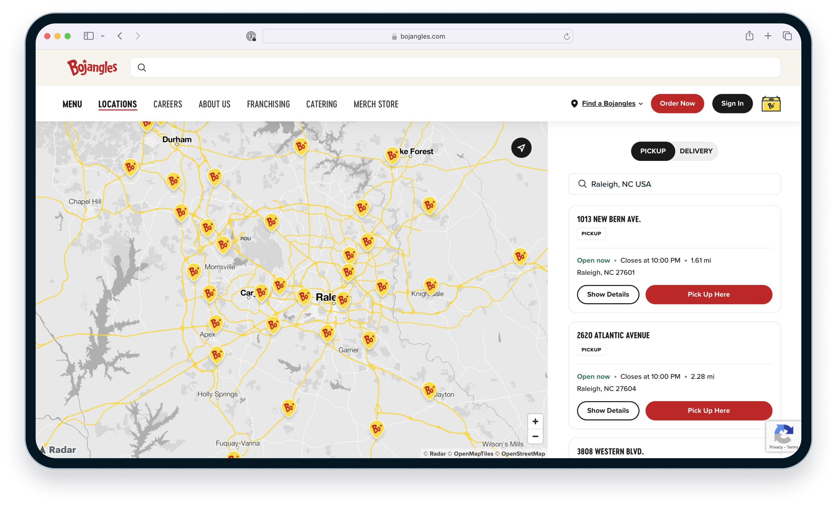
Check out this case study to learn how Bojangles cut their maps bill by 60% by switching to Radar.
From creating meaningful location experiences for our guests and our restaurants to saving almost 60% in cost, Radar's new Maps Platform will be a game changer for the industry. With this latest platform release, Radar has solidified their position as the premier all-in-one location platform.
— Sergio Perez, Senior Director of Omnichannel, Bojangles
Check out this case study to learn how DICK'S Sporting Goods also powers its Store Mode with Radar's Geofencing Platform.
Choosing Radar was easy. When you look at the geofencing industry, they are the clear leader in the space, and they continue to keep their foot on the gas when it comes to innovation.
— Matt Walker, Director of Product and Design, Mobile Apps, DICK'S Sporting Goods
