What is an isochrone map? A complete guide with examples and tutorials
What is an isochrone map?
An isochrone map shows areas that can be reached from a starting point within a given time. Think of it as a heat map for how far you can get in 5, 10, or 15 minutes.
For example, a restaurant operator might use an isochrone map to understand their delivery zone. A logistics platform might use one to define service areas. A real estate app might show which neighborhoods are accessible within a 30-minute commute.
Unlike simple radius maps that draw circles based on distance, isochrone maps reflect actual travel times, accounting for road networks, traffic, and mode of transportation. Isochrones are also a type of geofence that can be created using Radar's Geofencing Platform, ideal for travel-time-based experiences and insights.
How isochrone maps work
Isochrone maps are built using a few key inputs:
- Origin: A starting point, defined by a latitude and longitude.
- Travel mode: Driving, walking, biking, or truck.
- Time threshold: The number of minutes you want to map (e.g. 10, 20, 30 minutes).
From there, the map is generated using routing algorithms that analyze reachable roads or paths within the selected time. The result is a polygon showing all reachable areas, often shaped by real-world factors like traffic patterns or limited access roads.
.png)
Use cases for isochrone maps
Isochrone maps are useful for any business that operates in the physical world. They help teams analyze real-world accessibility, optimize operations, and deliver better experiences.
Logistics and delivery
For logistics teams, isochrone maps make service areas more accurate and reliable than radius-based zones. They help ensure timely deliveries and realistic ETAs.
- Define accurate delivery zones based on travel time.
- Optimize fleet dispatching and ETAs.
- Avoid overpromising service in hard-to-reach areas.
Learn more about Radar for logistics.
Retail and marketing
Retailers and marketers use isochrone maps to understand customer reach, improve campaign targeting, and plan smarter store placements.
- Analyze store catchment areas and customer access.
- Personalize campaigns based on reachability.
- Prioritize site selection based on local accessibility.
Learn more about Radar for retail.
Urban planning and transit
Urban planners and transit authorities use isochrone maps to analyze transportation equity and ensure access to essential services.
- Evaluate access to essential services like grocery stores and hospitals.
- Identify transit deserts or underserved communities.
- Perform equity analysis using reachability metrics.
Learn more about Radar for travel and transit.
Isochrone maps vs. radius maps
Many teams start with simple radius maps, drawing circles around a location with fixed distances (e.g. 5 miles). But real travel isn’t linear.
Isochrone maps are more accurate because they:
- Reflect travel time, not just distance.
- Consider road types, traffic, and direction.
- Create more realistic service areas.
Here’s a comparison:
How to build an isochrone map with Radar
Radar makes it easy to build isochrone maps and trigger geofence events based on travel time, not just distance.
Quickstart
1. Sign up for Radar and get your API key.
2. Create geofences. Define your geofences in the Radar dashboard or via the API. You can create standard geofences, polygons, or time-based (isochrone) geofences.
3. Integrate the SDK. Add the Radar SDK to your iOS, Android, or web app. Then call one of the following: // For a one-time location update
Radar.trackOnce()
// For continuous tracking
Radar.startTracking()
4. On the first qualifying location update inside a geofence, Radar will generate a geofence entry event.
How it works
Radar geofencing works in both the foreground and background. All event generation happens server-side, which allows for:
- Unlimited geofences.
- Polygon geofences.
- Isochrone (time-based) geofences.
- Temporary geofences.
- Stop detection.
This architecture makes Radar’s geofencing more powerful and flexible than native iOS or Android geofencing.
Here’s how geofence events work:
- Entry event: Generated when a user enters a geofence (if stop detection is off) or stops inside a geofence (if stop detection is on) with sufficient confidence.
- Exit event: Generated when a user leaves a geofence with sufficient confidence.
- Re-entry: A user must exit before another entry event is generated for the same geofence.
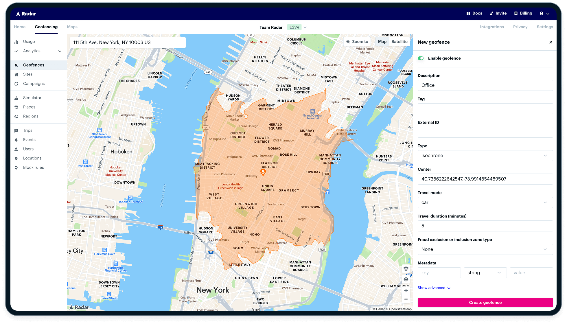
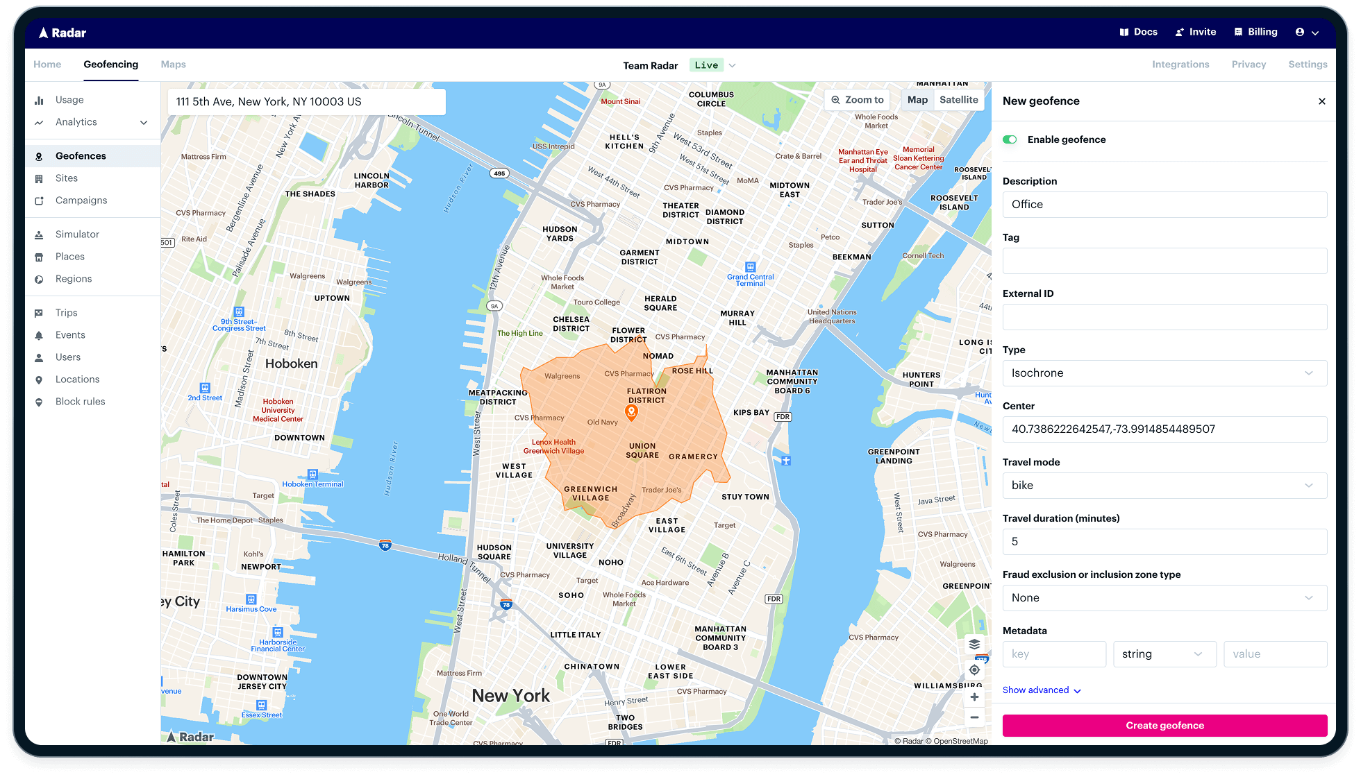
Creating isochrone geofences
Once your app is tracking location, you can create isochrone geofences in the Radar dashboard. These geofences are generated based on travel time rather than fixed distance.
When creating an isochrone geofence, you can define:
- Description: A human-readable label.
- Tag: Used to categorize geofences for analytics and filtering.
- External ID: Your internal reference for the geofence.
- Type: Set to
isochrone. - Center: Latitude and longitude of the origin point.
- Travel mode: Choose from
car,truck,motorbike,bike, orfoot.
Radar automatically calculates the travel-time polygon and starts triggering events based on user movement and app behavior.
Best practices for developers
Here are a few tips when building with isochrones:
- Cache results for common queries to avoid hitting rate limits.
- Use lower granularity for faster response times on large maps.
- Combine with geofencing to define dynamic service areas.
Layer with address data from Radar’s geocoding API.
Comparing isochrone APIs: Mapbox vs. Google vs. Radar
There are several options for building isochrone maps, but they differ in pricing, performance, and flexibility:
Radar’s isochrone API stands out for:
- Higher accuracy, thanks to our routing engine.
- Better pricing, with volume discounts and no per-request markup.
- Easy integration with our geofencing and maps platforms.
Getting started with Radar
Building isochrone maps with Radar takes just a few lines of code. If you're already using Radar for geofencing or maps, you can start right away.
FAQs
How accurate are isochrone maps?
Isochrone maps are as accurate as the routing engine and traffic data behind them. Radar uses real-time data to ensure high accuracy.
What’s the difference between isochrones and isodistances?
Isochrones are based on travel time, while isodistances are based on travel distance. Time is generally more useful for planning.
Which industries use isochrone maps most?
Logistics, retail, urban planning, and real estate teams rely on isochrone maps to optimize reach and service.