15 best reverse geocoding tools on the market today
Reverse geocoding takes latitude and longitude coordinates and turns them into familiar details, like a street address or a place name. Commonly used to pinpoint a user’s precise location when they drop a pin on a map or when searching for a nearby store, reverse geocoding is ubiquitous in online experiences.
Key features to look for in a reverse geocoding tool
Plenty of reverse geocoding services exist, but many come with drawbacks like high costs and accuracy concerns. In this piece we’ll highlight the top geocoding solutions on the market so you can choose the best option for your business.
Essential capabilities
- Batch geocoding: Essential for processing large datasets efficiently. This allows you to submit many requests at once instead of one by one.
- Language support: If your users are in different countries, the tool should return results in their local languages.
- Output formats: Ensure the tool provides results in formats your application can easily use (like JSON or XML).
- Customization: Some tools let you fine-tune the results, such as specifying the level of detail or prioritizing certain place types.
Data accuracy
- Precision: How close does the returned address match the actual location of the coordinates? Look for tools that offer rooftop-level accuracy or the ability to prioritize specific place types (e.g., residences, businesses) and return detailed address information, including the street name, house number, postal code, city, and country.
- Data sources: Where does the tool get its location data? Reputable sources and frequent updates are crucial for accuracy.
- Address validation: Does the tool verify and standardize addresses to ensure data quality? This is important for applications that rely on accurate address information.
Data coverage
- Geographic scope: Be clear about the regions you need. Some tools excel in specific countries, while others offer true global coverage.
- Point-of-interest (POI) data: If you need to identify nearby landmarks, businesses, or other points of interest, ensure the tool includes this data.
- Global coverage: For worldwide applications, confirm the tool's accuracy and data completeness in various countries and languages.
Performance
- Response times: Measured in milliseconds, this indicates how quickly the tool returns results. Faster is better, especially for real-time uses.
- Uptime and reliability: Look for service level agreements (SLAs) that guarantee high uptime (e.g., 99.9%) to ensure the tool is consistently available.
- Scalability: If you expect high volumes of requests, ensure the tool can handle them without performance degradation.
Pricing
- Free tier: Many tools offer a free tier for testing or low-volume use, allowing you to try before you buy.
- Pricing model: Common models include pay-as-you-go (per request) or monthly/annual subscriptions with usage tiers.
- Value for money: Balance the cost with the features, accuracy, and performance to get the best value.
Data privacy
This refers to how the reverse geocoding provider handles the data you send them (like the geographic coordinates you want to convert) and the data they return to you (the street address information).
Here's what to look for:
- Data ownership: Does the provider claim ownership of your data, or do you retain control?
- Data storage: Where and how is your data stored? Is it encrypted? Are there data retention policies?
- Data usage: Does the provider use your data for any purposes beyond providing the reverse geocoding service (e.g., analytics, marketing)?
- Compliance: Does the provider comply with relevant data privacy regulations (e.g., GDPR, CCPA)?
- Transparency: Do they have a clear and accessible privacy policy that explains their data practices?
Support and documentation
This is crucial for a smooth integration process and for troubleshooting any issues that may arise.
- Documentation: Is there comprehensive and well-organized documentation that explains how to use the API, including code examples and tutorials?
- Support channels: What support channels are available (e.g., email, phone, chat)? Are they responsive and helpful?
- Community: Is there an active community forum or developer community where you can get help from other users?
- SDKs and libraries: Does the provider offer SDKs or libraries in various programming languages to simplify integration?
Ease of integration
This refers to how straightforward it is to integrate the reverse geocoding API into your applications and workflows.
- API design: Is the API well-designed and easy to understand? Are the endpoints and parameters clearly defined?
- Data formats: Does the API support common data formats (JSON, XML) that are compatible with your systems?
- Code examples: Are there code examples in different programming languages to demonstrate how to use the API?
- Authentication: Is the authentication process simple and secure?
- Rate limits: Are the rate limits clearly defined and reasonable for your needs?
1. Radar
Radar is a location data platform that offers a variety of APIs and SDKs for developers, including a robust reverse geocoding tool. It aims to provide accurate and reliable location context while being a cost-effective alternative to some of the bigger players in the market.
Key features
- Global coverage: Radar provides address information for locations worldwide, drawing from a combination of open-source and commercial data sources.
- High accuracy: As precise as Google Maps, Radar strives for high accuracy, especially in populated areas.
- Address verification: Radar's reverse geocoding includes address verification capabilities to ensure the returned address is valid and standardized.
- Point-of-interest (POI) data: Along with the address, Radar can return nearby points of interest, providing additional context.
- Geofencing integration: A unique advantage of Radar is its seamless integration with its geofencing platform. This allows you to use reverse geocoding to determine if a location falls within predefined geofences.
See an example of converting coordinates into an address below:
Advantages of using Radar
- Cost-effectiveness: Radar is more affordable than Google Maps Platform and other location providers, especially for high-volume usage.
- Ease of use: The API is designed to be developer-friendly, with clear documentation and easy integration.
- Privacy-conscious: Radar places a strong emphasis on data privacy and security, giving users control over their location data.
- Combined functionality: Radar's platform offers a suite of location-based services, including geofencing, location tracking, and place search, making it a comprehensive solution.
Who should consider Radar?
- Cost-conscious developers: If cost is a major concern, Radar's competitive pricing makes it an attractive option for enterprises and small businesses.
- Businesses in need of geofencing: The seamless integration with Radar's geofencing platform is a significant advantage if your application involves location-based triggers or actions.
- Privacy-conscious companies: If data privacy is a priority, Radar's focus on user control and data security is a strong point.
2. Google Maps Platform
Highly accurate and reliable, providing detailed location information for locations worldwide. Leverages Google's vast data and sophisticated algorithms.
Key features
- Accuracy: Often pinpoints the exact address or building, even in complex urban environments.
- Global coverage: Works consistently across the globe, including remote areas.
- Rich data: Returns comprehensive address details, place types (e.g., restaurant, park), and Plus Codes for locations without formal addresses.
- Language support: Provides results in multiple languages, catering to diverse users.
3. Smarty
Known for its speed and precision, particularly in the US. Excels at matching geographical coordinates to precise addresses and validating them.
Key features
- Rooftop precision: Aims to identify the specific building or rooftop associated with the coordinates.
- Address validation: Checks and standardizes addresses to ensure data accuracy.
- US focus: While offering global coverage, its strength lies in its highly accurate US address data.
- Batch processing: Efficiently handles large volumes of reverse geocoding requests, ideal for bulk processing.
4. Geoapify
A cost-effective option with decent global coverage. Provides a straightforward way to convert coordinates into addresses.
Key features
- Affordability: Offers a free tier and competitive pricing, making it accessible for various budgets.
- Global coverage: Provides address lookups worldwide, though accuracy may vary.
- Ease of use: Simple API and clear documentation make it easy to integrate.
- OpenStreetMap data: Relies on OpenStreetMap, a community-driven and constantly updated data source.
5. Mapbox
Offers good global coverage and the ability to customize the returned data to some extent. Well-suited for developers seeking flexibility.
Key features
- Global coverage: Provides reliable address lookups worldwide.
- Customization options: Allows some control over the types of results returned (e.g., prioritizing certain place types).
- Developer-friendly: Offers robust APIs and SDKs for seamless integration.
- Contextual information: Can return additional data like points-of-interest (POIs) near the coordinates.
6. Bing Maps Platform
Microsoft's mapping service, offering global coverage and decent accuracy. A solid alternative to Google Maps Platform.
Key features
- Global coverage: Provides address information for locations worldwide.
- Point-of-interest (POI) data: Can return nearby points of interest along with the address.
- Multiple data sources: Combines data from various providers to enhance accuracy.
- Aerial imagery: Offers high-resolution aerial imagery for a visual context of the location.
7. TomTom Maps
Well-known for navigation systems, TomTom also provides a robust geocoding API with global reach.
Key features
- Global coverage: Accurate address data for locations worldwide.
- Traffic information: Can include real-time traffic data in responses, useful for applications where traffic conditions are relevant.
- Point-of-interest (POI) data: Provides access to a rich database of POIs.
- Automotive expertise: Strong focus on automotive applications, with features like speed limits and road geometry.
8. Geocodio
Specializes in US and Canadian addresses, with a strong emphasis on address validation and data cleaning.
Key features
- High accuracy in USA/Canada: Excels at providing precise address information in those regions.
- Address validation: Thoroughly verifies and standardizes addresses to improve data quality.
- Census data enrichment: Can append census demographic data to the address, providing valuable insights.
- Batch processing: Efficiently handles large volumes of reverse geocoding requests.
9. ArcGIS by Esri
A comprehensive Geographic Information System (GIS) platform with powerful geocoding capabilities. Often used in enterprise and government settings.
Key features
- Advanced geocoding: Offers a wide range of geocoding options, including street address, place name, and coordinate-based searches.
- Spatial analysis: Integrates with other GIS tools for spatial analysis and data visualization.
- Data management: Provides robust tools for managing and analyzing geographic data.
- Customization options: Highly customizable to meet specific needs and workflows.
10. Positionstack
A global reverse geocoding API that focuses on speed, accuracy, and ease of use. Suitable for various applications and scales.
Key features
- Global coverage: Provides accurate address data for locations worldwide.
- Fast response times: Optimized for speed, making it ideal for real-time applications.
- Bulk requests: Handles large volumes of reverse geocoding requests efficiently.
- Multiple languages: Returns results in various languages to cater to a global audience.
11. HERE Technologies
A comprehensive location platform with strong global coverage and a wide range of features beyond basic reverse geocoding.
Key features
- Global coverage: Accurate address data for locations worldwide, including remote areas.
- Rich location data: Provides detailed address information, place types, and points of interest.
- 3D maps: Offers 3D mapping capabilities for enhanced visualization and context.
- Industry solutions: Provides specialized solutions for industries like automotive, logistics, and transport.
12. Apple Maps
Integrated into Apple's ecosystem, offering reliable reverse geocoding functionality primarily for Apple devices and applications.
Key features
- High accuracy: Provides accurate address information, particularly in regions with good Apple Maps coverage.
- Privacy focus: Emphasizes user privacy and data security.
- Seamless integration options: Works seamlessly with other Apple services and frameworks.
- Offline maps: Allows users to download maps for offline use, enabling reverse geocoding even without an internet connection.
13. MapQuest
A long-standing mapping service that also offers a geocoding API with decent global coverage.
Key features
- Global coverage: Provides address data for locations worldwide.
- OpenStreetMap data: Relies on OpenStreetMap, a community-driven and constantly updated data source.
- Routing and directions: Offers routing and navigation capabilities in addition to reverse geocoding.
- Developer-friendly: Provides APIs and SDKs for easy integration into applications.
14. OpenCage Geocoding API
A forward and reverse geocoding API that prioritizes ease of use and clear, straightforward data. It's built on top of various open data sources, including OpenStreetMap.
Key features
- Global coverage: Provides address information for locations worldwide.
- Open data: Uses open data sources, promoting transparency and community involvement.
- Simple API: Easy to understand and integrate into applications.
- Flexible pricing: Offers a generous free tier for small-scale use and affordable plans for larger needs.
- Rate limiting: Clear usage limits to prevent abuse and ensure fair access.
15. OpenStreetMap Nominatim
The official geocoding service of OpenStreetMap. It's entirely free and open-source, allowing anyone to use or even host their own instance.
Key features
- Global coverage: Provides address information based on the extensive OpenStreetMap dataset.
- Community-driven: Relies on the collaborative efforts of the OpenStreetMap community for data updates and accuracy.
- Free and open-source: No cost to use and complete freedom to modify and redistribute.
- Scalability: Can be scaled to handle large volumes of requests, though this may require self-hosting.
- Detailed results: Returns rich data, including address components, place types, and OpenStreetMap IDs.
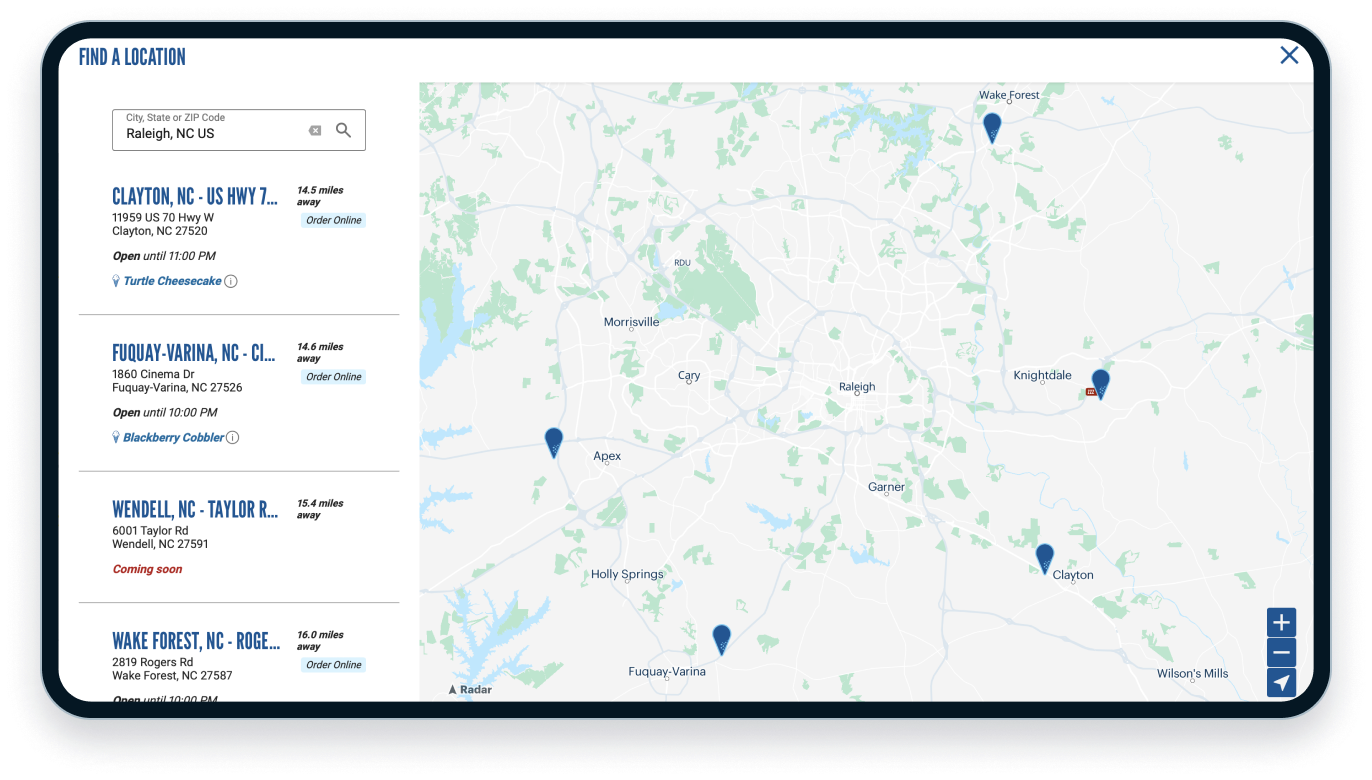
Radar: The #1 reverse geocoding tool
Thousands of companies trust Radar to power impactful location experiences across hundreds of millions of devices worldwide. From goefencing, geocoding, and maps, Radar is the all-in-one gelocation company.
See how brands like Bojangles and Culver's use geocoding for their store locators:
.png)
Reverse geocoding FAQs
Take a look at common reverse geocoding questions from small businesses and enterprises.
What makes reverse geocoding essential for modern apps?
Reverse geocoding is crucial for many apps that rely on location data. For example, ride-hailing apps use it to convert GPS coordinates into street addresses for pickup and drop-off locations, while navigation apps display the address of a user's current location or a destination. Food delivery apps rely on it to identify delivery addresses and provide estimated arrival times.
How can I use reverse geocoding to enhance location awareness in my application?
Reverse geocoding can enrich the location context in your app by providing detailed address information. By converting GPS coordinates into human-readable addresses, you can display the user's location more precisely, offer location-based services, or analyze geographic patterns in your data.
I need to display the time zone along with the address. Can reverse geocoding tools help with that?
Yes, many reverse geocoding APIs include time zone information in their results. This allows you to display the accurate local time for a given location, which can be useful for scheduling, event planning, or any application that deals with time-sensitive information.
Can reverse geocoding results include subdivisions, such as counties or neighborhoods?
Absolutely! Most reverse geocoding tools provide information about administrative subdivisions, like counties, states, and even neighborhood names. This granular level of detail can be valuable for location analysis, targeted advertising, or providing localized content.
How can I ensure the privacy of user data when using reverse geocoding in my app?
Choose a reverse geocoding provider, like Radar, with a strong commitment to data privacy. Look for features like data encryption, clear data retention policies, and compliance with data protection regulations. Always be transparent with users about how their location data is collected and used.