Fi saves six figures a year on maps APIs with Radar
By switching to Radar Maps Platform, Fi replaced two vendors with one, improved product accuracy, and is saving hundreds of thousands of dollars annually.
%20(1).webp)

$100K+
annual savings
99.99%
API uptime
The company
Fi builds smart collars that help dog owners keep their pets safe and healthy. Since launching in 2019, the company has focused on solving a core challenge: understanding what our dogs need when they can’t tell us themselves. Location is central to that mission. With real-time GPS tracking, Fi gives pet owners peace of mind, whether they’re reuniting with a lost dog or tracking daily walks. Today, Fi powers more than 150 million walks a year and has helped bring thousands of dogs home.
The challenge
Fi’s goal has always been to deliver precise, real-world visibility into a dog’s daily activity. As the team developed features that map out a dog’s exact walking route, they ran into limitations with their existing location providers.
Google’s APIs were built for driving directions, not for tracking a dog along the sidewalk. The GPS data Fi received often had a 10 to 20 foot margin of error, which made it hard to accurately show the side of the street or correct walking path. That level of accuracy didn’t meet Fi’s standard for user experience.
There was also no feedback loop. When routes were wrong, there was no easy way to submit examples or collaborate with Google to improve results. Fi needed more than a vendor. They needed a partner who could iterate on accuracy and build with them over time.
Fi was looking for a solution that not only reduced cost, but could also scale alongside their success without compromising accuracy.
The solution
Fi uses Radar Maps Platform to deliver accurate, real-time location updates to users at a lower cost and higher accuracy than legacy providers.
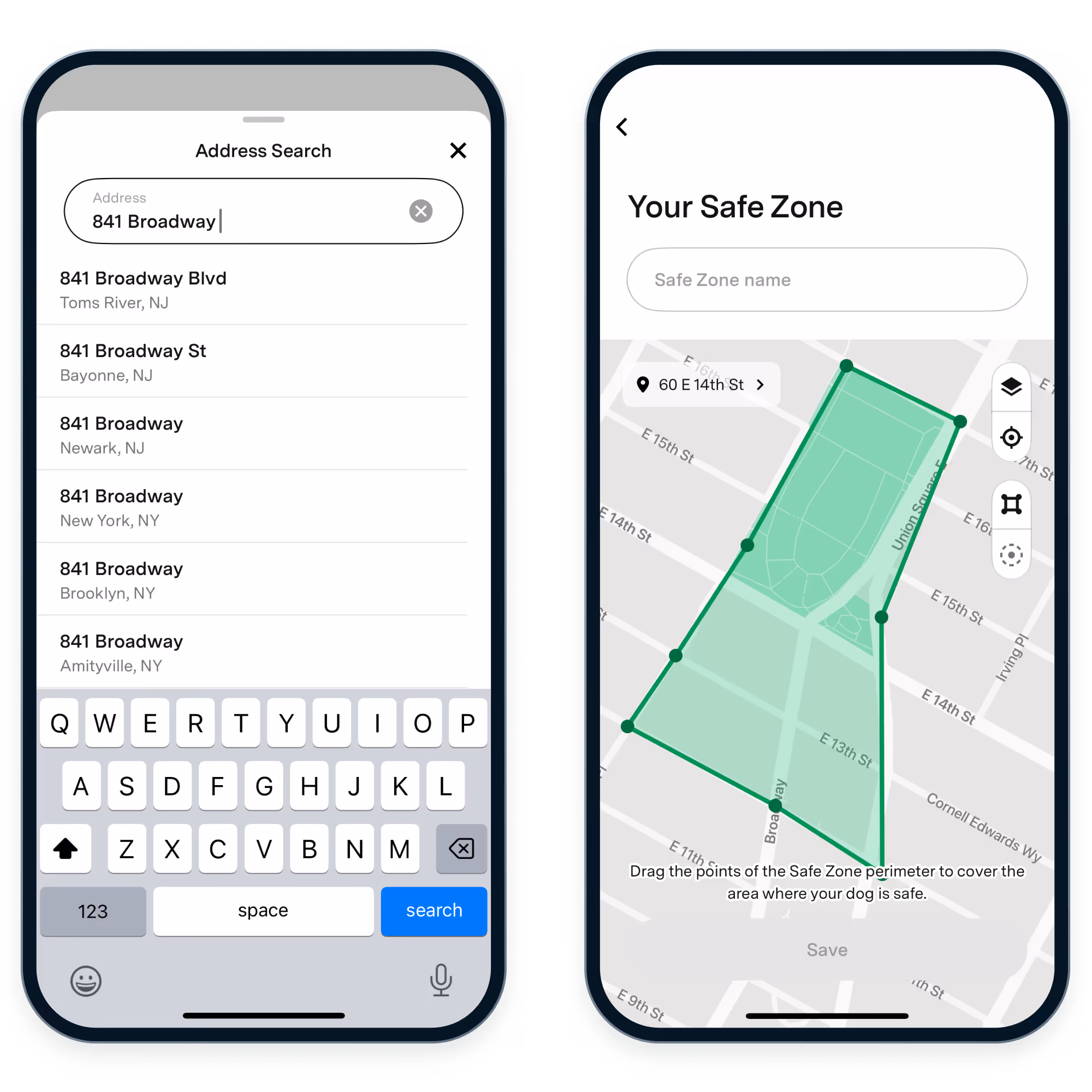
Radar now powers three key features in the Fi app:
- Reverse geocoding, which displays live collar locations as a full address. Fi migrated this functionality from Mapbox.
- Route matching, which draws walk paths and identifies which side of the street a dog (and their walker) is on. This was previously powered by Google.
- Address autocomplete, for selecting areas where your dog can roam freely, called Safe Zones, in their app.
Additionally, Radar worked with Fi to set up a direct pipeline for location issue reporting. When the support team identifies a walk route that looks off, they can send the data straight to an S3 bucket managed by Radar.
This system packages the relevant logs and GPS data in just a few clicks, giving Radar everything needed to investigate and improve route accuracy.
The results
By switching to Radar, Fi is saving hundreds of thousands of dollars per year on geolocation costs and delivering more accurate location data to their users.
Beyond accuracy and cost, Radar provides a level of support Fi didn’t have with previous providers. This creates a real feedback loop that allows both teams to iterate on map matching and improve the experience over time. With Google, this kind of hands-on collaboration was never an option.
Looking ahead
Fi is looking to explore Radar’s satellite maps to improve product quality and reduce costs. As Fi continues to invest in precision and clarity, Radar’s mapping tools will play a key role in how they integrate location functionality into their app.
“We replaced two vendors with one, made the product more accurate, and are saving hundreds of thousands of dollars a year. That’s the kind of efficiency we’re always looking for.”
Jonathan Bensamoun
CEO

It's time to build
See what Radar's location and geofencing solutions can do for your business.