6 location infrastructure platforms for apps in 2026
Choosing a location infrastructure platform used to mean picking a maps API and moving on. For most consumer apps and enterprise deployments today, that decision has become more consequential.
Location now underpins onboarding, discovery, checkout, fraud detection, compliance enforcement, real-time logistics, and personalized experiences. The platform you typically choose determines which of those use cases you can support without stitching together additional vendors.
In this roundup we took a deeper look at six platforms across the criteria that matter most for mobile app product teams: breadth of location capabilities, SDK quality, pricing structure, and fit for consumer and enterprise use cases.
You should note, this article was written by the team at Radar. We've done our best to evaluate each platform, including our own, to the same criteria. Where Radar might be the right fit, we say so. But where it isn't, we say that too.
Quick summary
How each platform was evaluated
We assessed each one across five dimensions:
- Geofencing and location tracking: Who offers native support for geofences, trip tracking, and arrival detection?
- Maps and geocoding: What is the quality and cost of map tiles, geocoding, address autocomplete, and routing?
- Geo-compliance and fraud prevention: Do they have the ability to enforce location-based rules and detect location manipulation?
- Developer experience: What's the SDK availability, documentation, and integration complexity?
- Pricing structure: What's the pricing predictability and total cost at scale?
1. Radar
Best for: Consumer apps across retail, QSR, financial institutions, gaming, travel, and logistics. Ideal for enterprise teams that need geofencing, maps, and geo-compliance in one SDK
Radar is an all-in-one location platform built to cover a full range of use cases. From geofencing and base maps to fraud prevention and a wide range of APIs, high growth startups and the Fortune 500 are powered by Radar. Where most platforms provide location data, Radar also acts on it.
Radar Geofencing
Radar Geofencing includes a global places database, support for custom polygon, circle, and isochrone geofences, and a trip tracking layer for on-demand delivery and curbside use cases. The places database allows teams to trigger on entries and exits into real-world locations and chains including restaurants, retailers, airports, and hotels, without manually drawing every geofence. Geofences run server-side, meaning evaluation doesn't depend on a persistent foreground process.
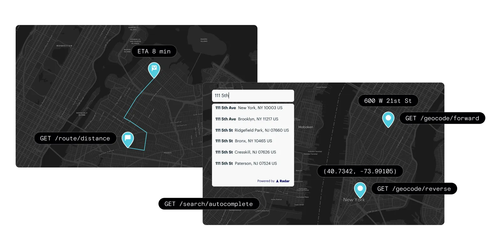
Radar Maps
Radar Maps covers address autocomplete, geocoding, reverse geocoding, routing, and base map tiles. Many teams switch from Google Maps and Mapbox to Radar because the APIs are a cost-effective alternative, with similar enterprise coverage.
Radar solutions
Beyond infrastructure, Radar has three solutions built on top of the same SDK that support use cases no other platform in this roundup covers natively. Where Mapbox, Google, HERE, and TomTom provide location data and stop there, Radar's solutions act on that data for engagement, operations, and fraud prevention.
- Radar Engage: Powers location-based messaging and personalized in-app experiences. Teams use Engage to trigger loyalty features, offers, and contextual content based on where a user is, whether that is entering a store, arriving at a venue, or completing a trip. No separate marketing automation tool is needed for location-triggered campaigns.
- Radar Optimize: Real-time trip tracking, worker tracking, and delivery management. Optimize gives operations teams visibility into pickups, deliveries, and fleet status, with accurate ETAs and tools to reduce cost and latency across last-mile workflows.
- Radar Protect: Location-based fraud prevention and geo-compliance, running natively inside the SDK. Protect detects GPS spoofing, mock location apps, VPN and proxy use, and emulator signals at the device layer. It also supports geo-compliance rules for regulated industries, letting platforms enforce location-based eligibility and block access from restricted regions without a separate fraud vendor. Teams in fintech, gaming, and travel use Protect to close the gap between when a location signal is collected and when it is acted on.
Developer experience
Single SDK across iOS, Android, React Native, and web. Radar provides a real-time dashboard, event logs, and a sandbox environment for testing geofence and trip tracking logic before going to production.
Limitations
- Radar is a newer entrant to the maps category compared to Google Maps
- International POI coverage is strong in North America but still maturing in some markets
- There are pricing minimums that may not suit very early-stage apps with minimal location usage
Pricing: Usage-based with enterprise agreements available, no per-SKU billing

2. Mapbox
Best for: Apps where custom map styling is a core product requirement
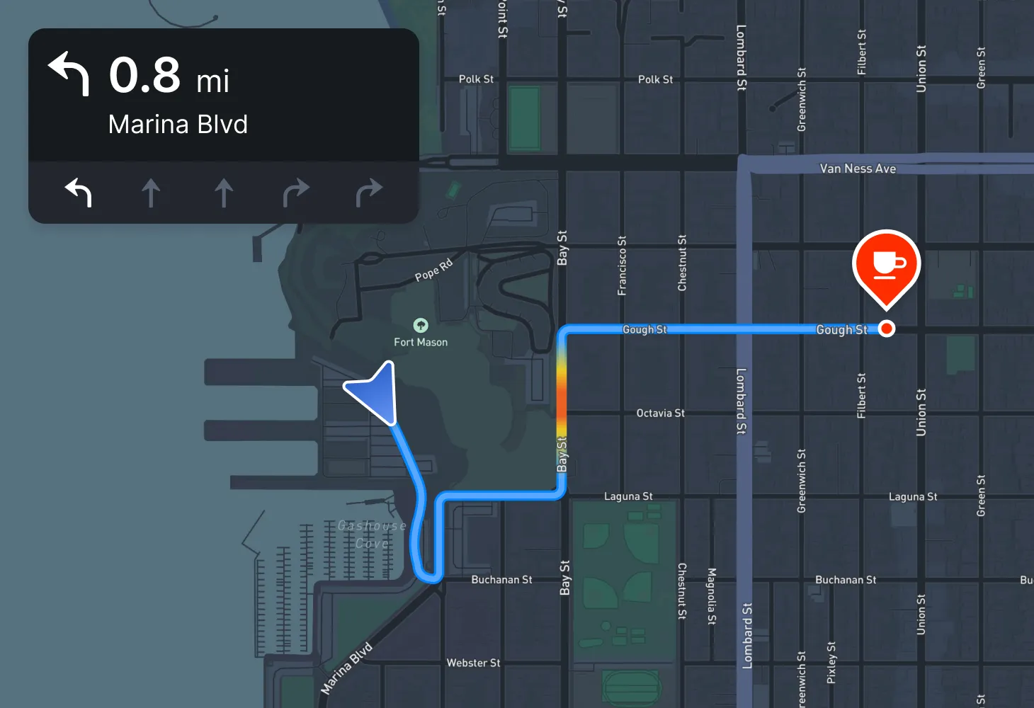
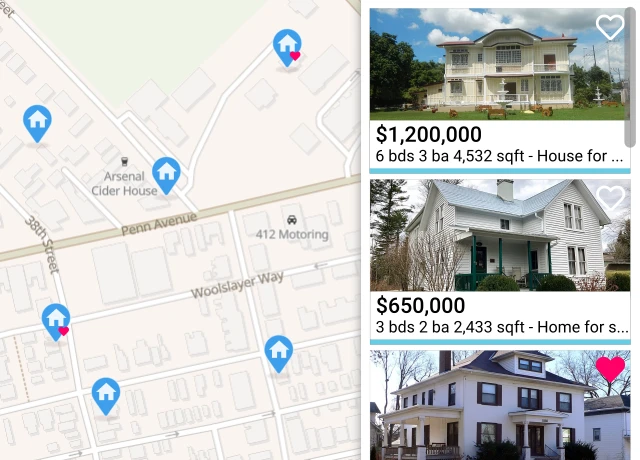
Mapbox built its reputation on cartographic flexibility. Its GL-based rendering engine and Mapbox Studio design tool give developers fine-grained control over the visual presentation of maps: color schemes, typography, layer visibility, and custom data overlays. For consumer apps where a branded map experience is central to the product, including navigation apps, real estate, and travel discovery, there's no doubt that Mapbox is the strongest option for visual customization.
The platform also covers geocoding, search, and turn-by-turn routing through its Navigation SDK.
Where Mapbox is thinner is in use cases beyond the map layer. They just launched a geofencing platform, but they don't offer location tracking SDK for enterprise workflows, and no fraud or compliance tooling.
Developer experience
Very strong ecosystem of open-source tools and an active developer community. Their tile-based architecture makes it very performant for complex, data-heavy maps
Limitations
- Metered per-request pricing across multiple APIs becomes significant at scale, particularly for apps with high geocoding or search volumes
- The pricing model also lacks flexibility in the other direction: teams with lower or variable API usage have limited options to right-size their spend
- Limited geofencing and no compliance capabilities
Pricing: Pay-as-you-go, per-request
3. HERE Technologies
Best for: Enterprise logistics, fleet management, and automotive applications
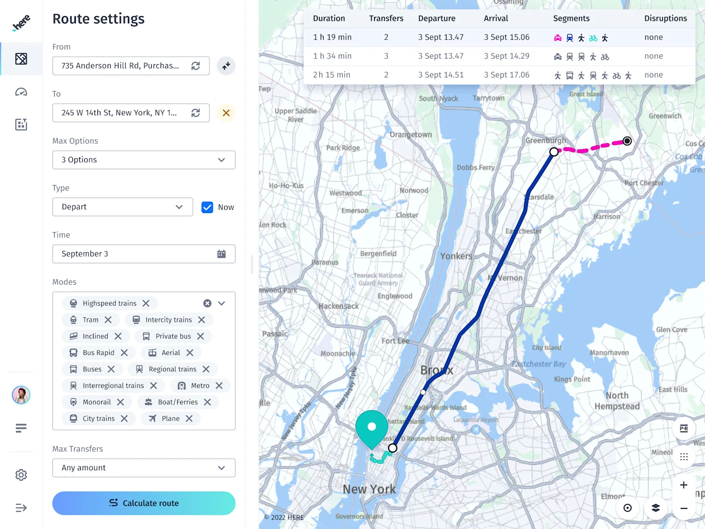
HERE has one of the deepest routing and navigation datasets available, with particular strength in real-time traffic, truck routing, and automotive-grade map data. For enterprises building fleet management systems, in-vehicle navigation, or large-scale logistics applications, HERE's data fidelity is difficult to match.
The platform is less accessible for consumer mobile app teams, and the developer experience is definitely more complex than Mapbox or Radar. With pricing primarily structured for enterprise licensing rather than API-level access, the product roadmap is oriented toward automotive and logistics rather than consumer app use cases. There is no native geofencing platform and no fraud or compliance layer.
Developer experience
HERE's developer portal provides REST APIs and SDKs across its product surface, but the breadth of the platform can make it harder to navigate than API-first alternatives. Documentation is comprehensive but oriented toward enterprise and automotive use cases, and onboarding typically involves more configuration and coordination than platforms built for self-serve developer access. Teams not already familiar with HERE's ecosystem should factor in additional ramp-up time.
Limitations
- Complex onboarding relative to API-first alternatives
- Primarily enterprise-licensed, which can be a barrier for smaller teams
- No geofencing, tracking, or compliance capabilities
Pricing: Enterprise licensing
4. Google Maps Platform
Best for: Consumer apps where broad data coverage and recognizable map presentation matter most
Google Maps Platform remains the default choice for teams that need globally reliable map data, POI coverage, and Street View imagery. For consumer apps where map display is a primary feature and the team is already invested in the Google Cloud ecosystem, it's the lowest-friction starting point.
Their maps coverage is best-in-class, with 250+ countries and territories. Data is updated frequently, so it's great for consumer-facing apps and international use cases. Visuals for street view, satellite imager, and 3D map products continue to get richer. Location experiences feel very polished.
The primary challenge is cost architecture. Every capability, including geocoding, places, directions, and Street View, is priced as a separate SKU with rates ranging from $2 to $30 per 1,000 requests depending on the API. Bills become difficult to predict at scale when multiple SKUs are triggered per user session.
For teams with high call volumes, particularly in address search and autocomplete, the per-request pricing model is frequently the reason they evaluate alternatives.
Developer experience
Google Maps Platform has one of the largest developer communities of any mapping product, with extensive documentation, tutorials, and third-party resources. The APIs are well-structured and broadly familiar to most front-end developers, which makes initial integration fast.
Limitations
- Per-SKU pricing creates unpredictable costs at scale
- No purpose-built geofencing or location tracking
- No fraud or compliance tooling
Pricing: Pay-as-you-go, per API SKU, ranging from $2 to $30 per 1,000 requests

5. Geoapify
Best for: Early-stage apps or internal tools with modest location requirements and tight budgets
Geoapify provides geocoding, reverse geocoding, routing, isochrone APIs, and map tiles at a price point significantly below tier-1 providers. For teams building MVPs, internal tooling, or low-traffic applications where location is a secondary feature, it is a reasonable way to avoid Google Maps pricing before scale demands a more robust option.
It's not a production-ready option for consumer apps at scale. Reliability and data quality are below what Google, HERE, Mapbox, or Radar offer. There is no geofencing platform, no location tracking, and no fraud or compliance capability.
Developer experience
Geoapify offers a straightforward REST API with decent documentation for its core capabilities. It is well-suited to developers who need to get something running quickly without a complex onboarding process. The trade-off is limited support resources: there is no dedicated support channel or community comparable to larger platforms, and troubleshooting at the edges of the API surface can require more independent investigation.
Limitations
- Data quality and reliability at scale do not match tier-1 providers
- Limited enterprise support
- No geofencing, tracking, or compliance tooling
Pricing: Freemium with usage-based paid tiers
6. TomTom
Best for: Automotive navigation, EV routing, and enterprise fleet applications
TomTom's primary strength is navigation and routing data, with particular depth in real-time traffic, road closures, and EV-specific routing that accounts for charging station availability and vehicle range. For automotive manufacturers and fleet operators where navigation accuracy is the core requirement, TomTom is a well-established option.
Like HERE, TomTom is primarily oriented toward automotive and enterprise logistics rather than consumer mobile app development. The developer onboarding experience is more involved than API-first platforms, pricing is enterprise-licensed, and there's no native geofencing, tracking, or compliance capability.
Developer experience
TomTom provides SDKs and APIs for maps, routing, and search with documentation oriented toward navigation and automotive use cases. The developer tooling is more accessible than HERE's for teams building routing or EV-specific features, but less suited to general consumer mobile app development. Community resources and third-party integrations are thinner than Google Maps or Mapbox, which can slow down troubleshooting for teams new to the platform.
Limitations
- Primarily automotive-oriented
- No geofencing or compliance layer
- Enterprise licensing model is less accessible for app teams outside automotive and fleet
Pricing: Enterprise licensing
What's right for you?
If you're building a consumer app with geofencing, delivery, loyalty, or compliance requirements Radar covers this use case natively across geofencing, maps, and fraud prevention in a single SDK, avoiding the multi-vendor architecture that most alternatives require.
If custom map styling is central to your product experience Mapbox's rendering engine and Studio design tool are the most flexible option for teams where visual map customization is a first-order requirement.
If you're building enterprise logistics, fleet management, or in-vehicle navigation HERE and TomTom both offer deep routing and navigation data built for these use cases. HERE has broader global coverage; TomTom has stronger EV routing and real-time traffic depth.
If you need broad consumer map data and are already in the Google Cloud ecosystem Google Maps Platform is the default for teams where map display is the primary use case and engineering resources for managing cost complexity are available.
If you're at early stage and just need basic geocoding and maps Geoapify and Google Maps are the lowest-friction starting points. Factor in that Google's per-SKU pricing compounds at scale before committing to a long-term architecture.
If you operate in a regulated industry or need to detect location fraud Only Radar offers native geo-compliance and location-based fraud prevention. Every other platform in this roundup requires a separate fraud vendor to cover this layer, adding integration complexity, additional cost, and a gap between when the location signal is collected and when it is acted on.
Scaling with your location infrastructure
Most mobile app teams start their location infrastructure decision with a maps API. The more useful question is what else the platform needs to do with location data. Geofencing, trip tracking, address search, fraud prevention, and compliance enforcement are all downstream of that choice, and they determine how many vendors are required and how complex the stack becomes.
For teams that need the full range of location capabilities, particularly those building in regulated categories or high-fraud-risk verticals, Radar is the only platform in this roundup that covers geofencing, maps, geo-compliance, and fraud detection in a single integration.